File:Korea 2003-05-01 NASA MODIS Terra 250m.jpg

本预览的尺寸:443 × 599像素。 其他分辨率:177 × 240像素 | 355 × 480像素 | 568 × 768像素 | 757 × 1,024像素 | 1,514 × 2,048像素 | 3,400 × 4,600像素。
原始文件 (3,400 × 4,600像素,文件大小:1.47 MB,MIME类型:image/jpeg)
摘要
| 描述 |
Français : Image satellite de la Corée le 1er mai 2003 par le satellite Terra du programme MODIS de la NASA, résolution 250m
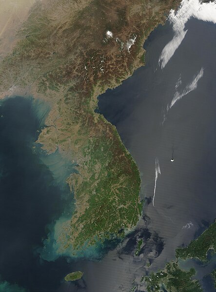
English: This Moderate Resolution Imaging Spectroradiometer (MODIS) image from May 1, 2003, shows southeastern China (top), North Korea (center) and South Korea (bottom). The higher elevations and more northern latitudes are lagging behind the new growth of spring vegetation visible across South Korea. Large areas of North Korea, especially the western coast, are deforested, probably contributing to the large volumes of sediment run-off swirling in the coastal waters. A few scattered fires have been marked with red dots. Resolution 250m |
| 日期 | |
| 来源 | NASA's Visible Earth, https://visibleearth.nasa.gov/images/66392/korea |
| 作者 | Jeff Schmaltz, MODIS Rapid Response Team, NASA/GSFC |
| 相机位置 | | 在以下服务上查看本图像和附近其他图像: OpenStreetMap |
|---|
许可协议
| 本文件完全由NASA创作,在美国属于公有领域。根据NASA的版权方针,NASA的材料除非另有声明否则不受版权保护。(参见Template:PD-USGov/zh、NASA版权方针页面或JPL图片使用方针。) | ||
 |
警告:
|
文件历史
点击某个日期/时间查看对应时刻的文件。
| 日期/时间 | 缩略图 | 大小 | 用户 | 备注 | |
|---|---|---|---|---|---|
| 当前 | 2023年9月25日 (一) 07:18 | | 3,400 × 4,600(1.47 MB) | Koreller | Uploaded own work with UploadWizard |
文件用途
以下页面链接到本图像:
全域文件用途
以下其他wiki使用此文件:
- ar.wikipedia.org上的用途
- ast.wikipedia.org上的用途
- az.wikipedia.org上的用途
- bn.wikipedia.org上的用途
- ca.wikipedia.org上的用途
- csb.wikipedia.org上的用途
- cs.wikipedia.org上的用途
- de.wikipedia.org上的用途
- en.wikipedia.org上的用途
- en.wikiquote.org上的用途
- en.wiktionary.org上的用途
- eo.wikipedia.org上的用途
- es.wikipedia.org上的用途
- eu.wikipedia.org上的用途
- fi.wikipedia.org上的用途
- fr.wikipedia.org上的用途
- ga.wikipedia.org上的用途
- he.wikipedia.org上的用途
- hr.wikipedia.org上的用途
- hu.wikipedia.org上的用途
- hy.wikipedia.org上的用途
- ia.wikipedia.org上的用途
- it.wikipedia.org上的用途
- ja.wikipedia.org上的用途
- ko.wikipedia.org上的用途
- min.wikipedia.org上的用途
- ms.wikipedia.org上的用途
- nds.wikipedia.org上的用途
- no.wikipedia.org上的用途
- pl.wikipedia.org上的用途
- pl.wiktionary.org上的用途
- pnb.wikipedia.org上的用途
- pt.wikipedia.org上的用途
- roa-tara.wikipedia.org上的用途
- ru.wikipedia.org上的用途
- ru.wikinews.org上的用途
查看本文件的更多全域用途。