File:Map of the world by the US Gov as of 2016.svg

此SVG文件的PNG预览的大小:800 × 434像素。 其他分辨率:320 × 174像素 | 640 × 347像素 | 1,024 × 555像素 | 1,280 × 694像素 | 2,560 × 1,389像素 | 3,464 × 1,879像素。
原始文件 (SVG文件,尺寸为3,464 × 1,879像素,文件大小:25.19 MB)
摘要
| 描述 |
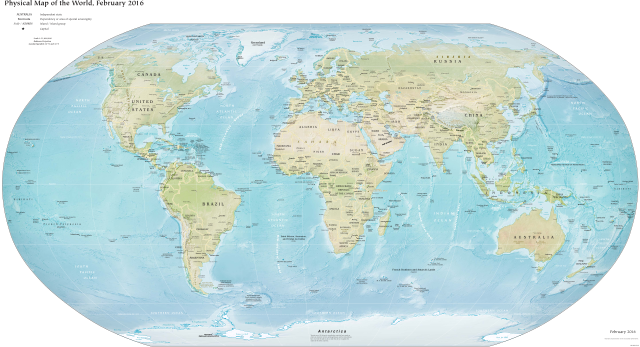
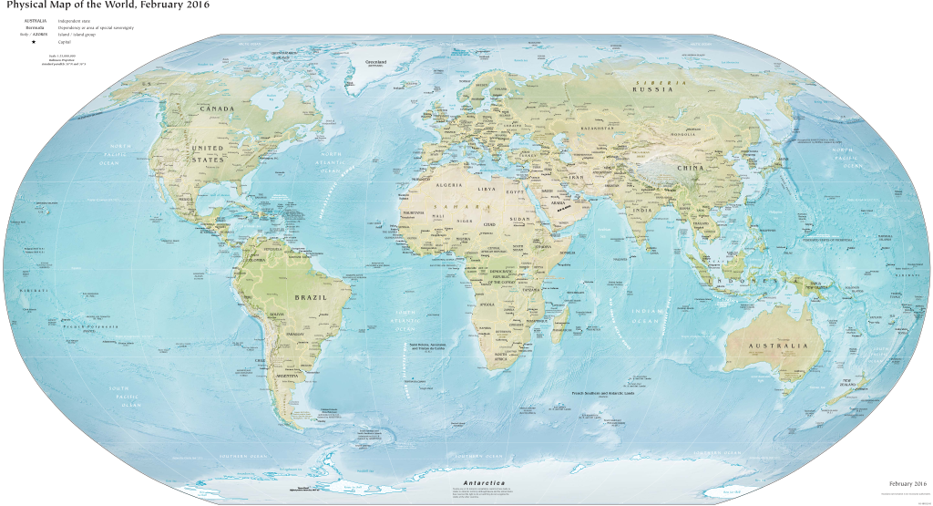
English: Map of the world as released by the United States Government, February 2016. Robinson projection, standard parallels 38°N and 38°S.
English: Carte du monde realisee par le Gouvernement des Etats-Unis en 2016 |
| 日期 | |
| 来源 | CIA World Factbook |
| 作者 | US Government, Central Intelligence Agency |
| 其他版本 |
|
许可协议
此作品在美国属于公有领域,因为其是由美国政府的官员或雇员,基于其个人公务目的制作的作品,参考美国法典第17篇第1章第105条。
注意︰本模板仅适用于美国联邦政府的原创作品,不适用于任何美国州、属地、联邦个体、县、市或任何次级政府的作品。本模板也不适用于1978年以后由美国邮政署出版的邮票图案(参看美国版权局实践纲领第313.6(C)(1)条)。也不适用于部分美国硬币;参看美国铸币局使用条款。 |
 | |
| 本文件已被确认为免除已知的著作权法限制(包括所有相关权利)。 | ||
文件历史
点击某个日期/时间查看对应时刻的文件。
| 日期/时间 | 缩略图 | 大小 | 用户 | 备注 | |
|---|---|---|---|---|---|
| 当前 | 2018年10月1日 (一) 01:40 | | 3,464 × 1,879(25.19 MB) | SpanishSnake | crop |
| 2018年4月23日 (一) 14:10 |  | 4,320 × 3,240(22.22 MB) | L293D | User created page with UploadWizard |
文件用途
以下页面链接到本图像:
全域文件用途
以下其他wiki使用此文件:
- bjn.wikipedia.org上的用途
- bn.wikipedia.org上的用途
- en.wikipedia.org上的用途
- fa.wikipedia.org上的用途
- fj.wikipedia.org上的用途
- id.wikipedia.org上的用途
- lmo.wikipedia.org上的用途
- min.wikipedia.org上的用途
- ml.wikipedia.org上的用途
- mni.wikipedia.org上的用途
- mnw.wikipedia.org上的用途
- ms.wikipedia.org上的用途
- nds-nl.wikipedia.org上的用途
- ne.wikipedia.org上的用途
- qu.wikipedia.org上的用途
- rue.wikipedia.org上的用途
- simple.wikipedia.org上的用途
- si.wikipedia.org上的用途
- th.wikipedia.org上的用途
- tl.wikipedia.org上的用途
- tr.wikipedia.org上的用途
- tw.wikipedia.org上的用途
- uk.wikipedia.org上的用途
- vi.wikipedia.org上的用途