File:North America from low orbiting satellite Suomi NPP.jpg

預覽大小:600 × 600 像素。 其他解析度:240 × 240 像素 | 480 × 480 像素 | 768 × 768 像素 | 1,024 × 1,024 像素 | 2,048 × 2,048 像素 | 8,000 × 8,000 像素。
原始檔案 (8,000 × 8,000 像素,檔案大小:16.43 MB,MIME 類型:image/jpeg)
摘要
| 警告 | 部分瀏覽器在瀏覽此圖片的完整大小時可能會遇到困難:該圖片中有數量巨大的像素點,可能無法完全載入或者導致您的瀏覽器停止回應。 |
|---|
| 描述 |
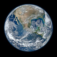
English: A view of most of North America taken from a low orbit of about 826 km altitude. The whole hemisphere is not visible owing to the low orbit, and the horizon is at a distance of about 3,300 km, while the radius of the planet is 6,371 km. The diameter seen from this height is about 125 degrees.
An image of the Earth taken from the VIIRS instrument aboard NASA's Earth-observing research satellite, Suomi NPP. This composite image uses a number of swaths of the Earth's surface taken on 4 January 2012. The NPP satellite was renamed 'Suomi NPP' on 24 January 2012 to honour the late Verner E. Suomi of the University of Wisconsin. Suomi NPP carries five instruments on board. The biggest and most important instrument is The Visible/Infrared Imager Radiometer Suite or VIIRS.
Español: Una vista de la mayor parte de América del Norte tomada desde una órbita baja. Esta vista resulta de una altura del satélite que está a unos 826 kilómetros por encima de la superficie de la Tierra. Debido a la órbita baja el hemisferio no es totalmente visible, y el horizonte se encuentra en una distancia de tan sólo aproximadamente 3300 km, mientras que el radio de nuestro planeta es 6371 kilómetros. El diámetro del horizonte visto desde esta altura es de aproximadamente 125 grados. |
||||
| 日期 | |||||
| 來源 |
http://www.nasa.gov/multimedia/imagegallery/image_feature_2159.html; SEE Also => http://solarsystem.nasa.gov/multimedia/display.cfm?IM_ID=9643 AND http://solarsystem.nasa.gov/planets/profile.cfm?Object=Earth |
||||
| 作者 | NASA/NOAA/GSFC/Suomi NPP/VIIRS/Norman Kuring | ||||
| 其他版本 |
|

.jpg)
|
This image was selected as picture of the day on Wikimedia Commons for 22 April 2014. It was captioned as follows: English: On Earth Day, a view of most of North America taken from a low orbit of about 826 km altitude aboard NASA's Earth-observing research satellite, Suomi NPP. Other languages:
Bosanski: Fotografija načinjena na Dan planete Zemlje, pogled na veći dio Sjeverne Amerike iz niske orbite od oko 826 km iznad površine iz NASA-inog satelita za istraživanje Zemlje Suomi NPP. Čeština: Na dnešní den: Den Země, pohled na Severní Ameriku z nízké oběžné dráhy z výšky kolem 826 km, snímek z meteorologického satelitu Suomi NPP. English: On Earth Day, a view of most of North America taken from a low orbit of about 826 km altitude aboard NASA's Earth-observing research satellite, Suomi NPP. Italiano: L'America settentrionale fotografata in orbita bassa nella Giornata della Terra dal satellite di ricerca Suomi NPP. Magyar: A Föld napja: Észak-Amerika nagyobb részének képe, amely a NASA egyik alacsony pályán, mintegy 826 km magasságban keringő Föld-megfigyelő műholdjáról, a Suomi NPP-ről készült Nederlands: Op de Dag van de Aarde een blik op Noord-Amerika vanaf een lage baan op 826 kilometer hoogte vanuit de NASA-satelliet Suomi NPP. 中文: 世界地球日,美国宇航局的地球观测卫星在低轨道826公里处拍摄的北美洲大部分地区的照片。 |
授權條款
| 本作品由NASA創作,屬於公有領域。根據NASA的版權政策:“NASA的創作除非另有聲明否則不受版權保護。”(參見:Template:PD-USGov/zh,NASA版權政策或JPL圖像使用政策) | ||
 |
警告:
|
檔案歷史
點選日期/時間以檢視該時間的檔案版本。
| 日期/時間 | 縮圖 | 尺寸 | 使用者 | 備註 | |
|---|---|---|---|---|---|
| 目前 | 2012年1月26日 (四) 04:03 | | 8,000 × 8,000(16.43 MB) | Hellbus | {{Information |Description ={{en|1=A 'Blue Marble' image of the Earth taken from the VIIRS instrument aboard NASA's most recently launched Earth-observing satellite - Suomi NPP. This composite image uses a number of swaths of the Earth's surface taken |
檔案用途
下列頁面有用到此檔案:
全域檔案使用狀況
以下其他 wiki 使用了這個檔案:
- af.wikipedia.org 的使用狀況
- ar.wikipedia.org 的使用狀況
- as.wikipedia.org 的使用狀況
- az.wikiquote.org 的使用狀況
- be-tarask.wikipedia.org 的使用狀況
- bn.wikipedia.org 的使用狀況
- crh.wikipedia.org 的使用狀況
- cv.wikipedia.org 的使用狀況
- de.wikipedia.org 的使用狀況
- el.wikipedia.org 的使用狀況
- en.wikipedia.org 的使用狀況
- The Blue Marble
- Portal:Energy
- Portal:Energy/Energy topics
- User:Northamerica1000
- Portal:Society/Featured article
- User talk:Semccraw
- User talk:Jesusserrano
- User talk:Bmbrooks
- User talk:Bhaluska
- User talk:Ependell
- User talk:Mmutterperl
- User talk:Kaylaek
- User talk:Tjohns17
- User talk:BellaBeast
- User talk:JessicaSG
- User talk:Laurenm2
- User talk:Jessgutman
- User talk:Lissyh1990
- User talk:Maxsasaki
- User talk:Aebarone
- User talk:Emackin
- User talk:Lmfye
- User talk:EauroraUA
- User talk:Jaallen1
- User talk:Dkunst
- User talk:Girg45
- User talk:Cindyy1
- User talk:Aglick
- Suomi NPP
- User:Cullen328/Welcome
- Wikipedia:Featured picture candidates/February-2012
- User talk:Sdmuszyn
- User talk:Allieglock
- User talk:Cpatel623
- User talk:Darrinbrink
檢視此檔案的更多全域使用狀況。